About GPS Map Camera Geotag Location
GPS Map Camera Geotag Location app is the best way to keep tags of address and precise location on your photo. GPS Map Camera Geotag Location App is a powerful tool that captures the live location details with the camera....
GPS Map Camera Geotag Location app is the best way to keep tags of address and precise location on your photo.
GPS Map Camera Geotag Location App is a powerful tool that captures the live location details with the camera.
This app not only helps users keep memories in detail with perfect places but also enhances their photography experience by enabling precise location tagging.
This GPS Map Camera Geotag Location will provide all the current location details with tags in photos and you can save all your created files into my creation folder.
The GPS Map Camera Geotag Location App is the best tool for anyone who wishes to navigate the world with precision, document their journeys, and enhance their photography experience.
Now enhance your anytime photography by using this amazing GPS Camera Location tool which allows a variety of tag templates to enhance your photography with the best tags.
Simple and easy-to-use app allows you to cover live location details in a photo clip.
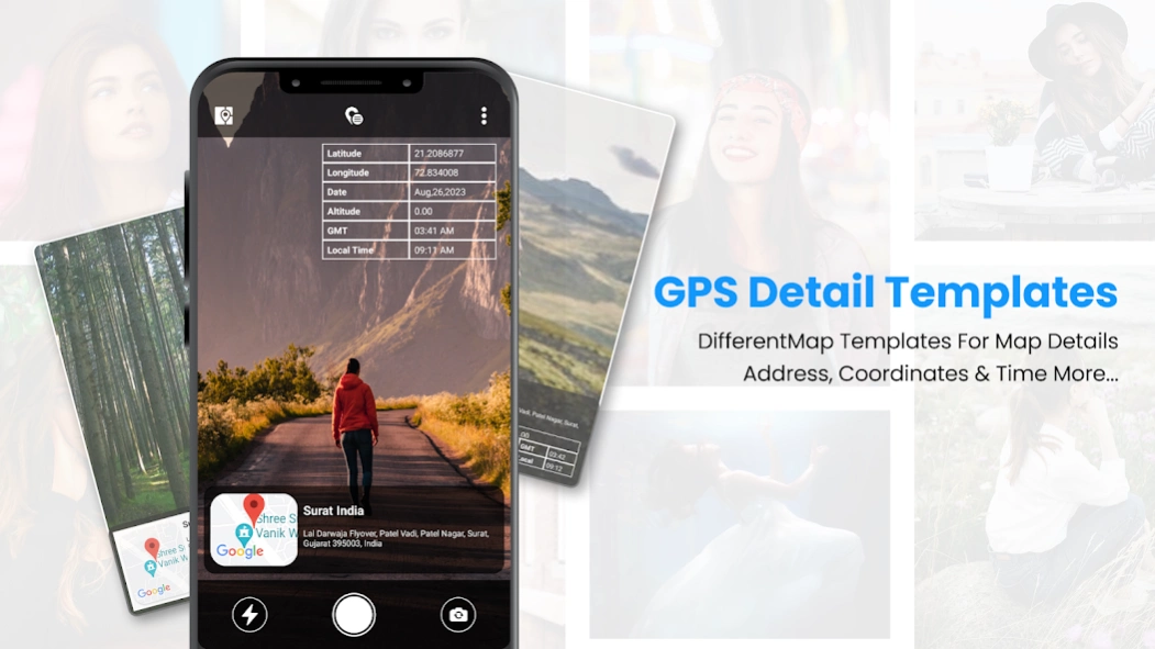
GPS Map Camera Geotag Location also provides map data in which you find the exact location where you are and also find the latitude, longitude, address, city, state, and country details with just a click.
One of the best ways to create and save the memories where you travel last.
Features of the GPS Map Camera Geotag Location App
The app provides users with accurate GPS navigation
The app can pinpoint your location and provide turn-by-turn directions
App allows to add tag the exact location where a photo was taken
Easily shared with friends and social media followers
Easy to add tags to photos
Find different tags template collection
Easy to save collected images in the app creation folder
Map Data to find accurate locations on map
Add tag details like latitude, longitude, date, altitude, GSM, location address, and time
Clear UI Design and easy-to-use app.
Previous Versions
Here you can find the changelog of GPS Map Camera Geotag Location since it was posted on our website on 2023-12-24 09:53:06.
The latest version is 3.0 and it was updated on 2024-04-23 11:16:13. See below the changes in each version.
GPS Map Camera Geotag Location version 3.0
Updated At: 2023-12-28
Disclaimer
Official Google Play Link
We do not host GPS Map Camera Geotag Location on our servers. We did not scan it for viruses, adware, spyware or other type of malware. This app is hosted by Google and passed their terms and conditions to be listed there. We recommend caution when installing it.
The Google Play link for GPS Map Camera Geotag Location is provided to you by apps112.com without any warranties, representations or guarantees of any kind, so access it at your own risk.
If you have questions regarding this particular app contact the publisher directly. For questions about the functionalities of apps112.com contact us.